Stuart West Ridge 8/25/06
When my North Ridge Stuart climb fell apart, I weaseled my way onto Vincent Dunn's Chemeketan climb on West Ridge (thanks, guys, especially Susan!)
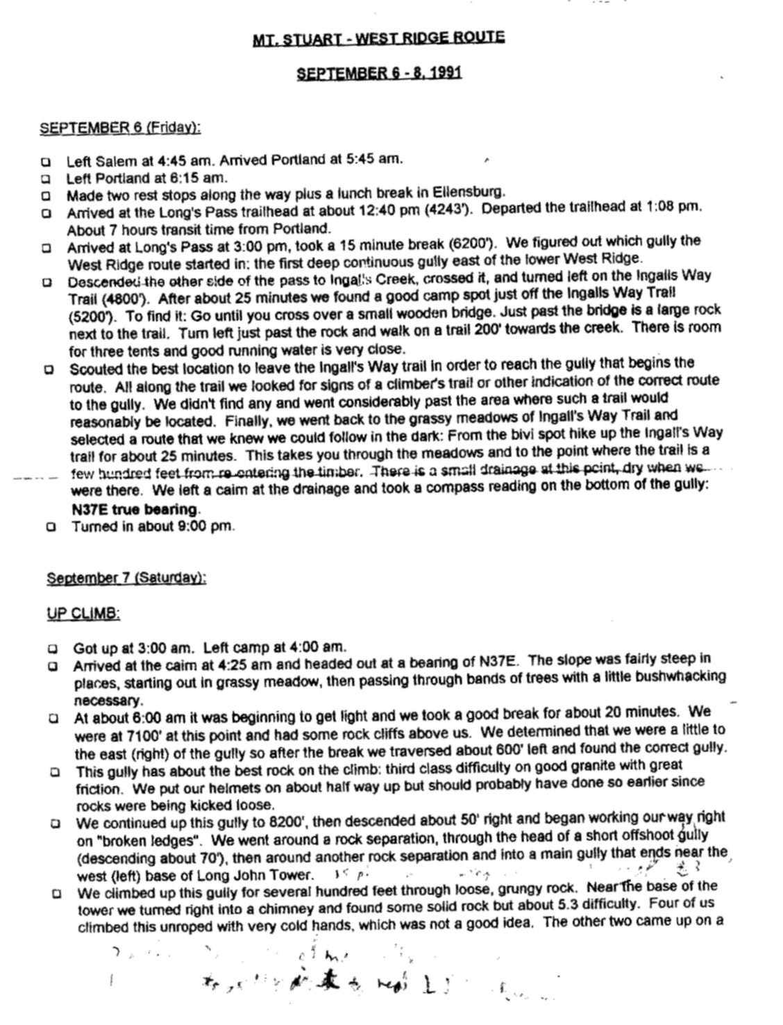
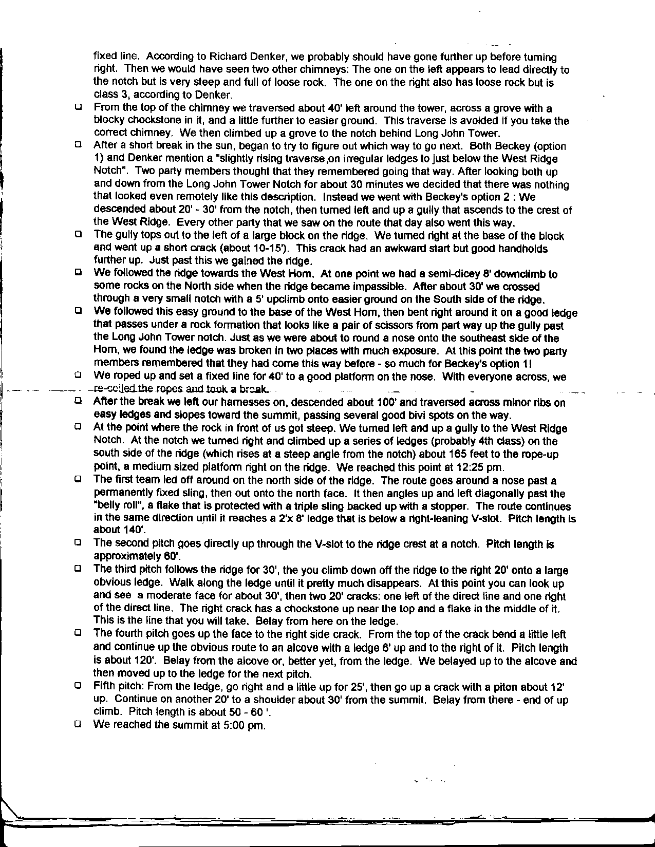
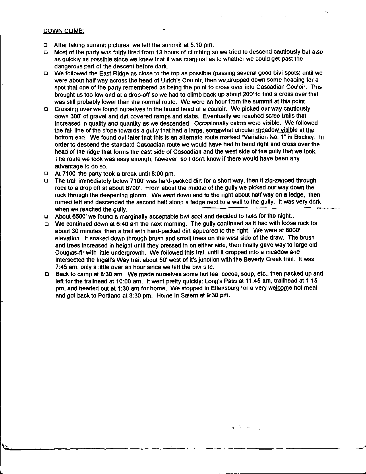
West Ridge is pretty easy rock climbing, lots of it - it's notorious for routefinding ("innumerable variations" says Beckey). Here are scans of some notes compiled by several Mazama climb leaders, left over from my two prior failed attempts with the climb (on which I never did eny actual climbing on the route!):
page 1
page 2
page 3
Chronology:
Lv cars: 2:20
lake: ~5:30
camp at top of ridge trail/pass: 7:30-8PM

leave camp: 6:30AM
long john tower notch: 10:30
West Ridge notch: 1:00 (lost 1 hour routefinding)
summit: 4:45
leave: 5:15
break at top of quartz slabs in Cascadian: 7:30
trail 8:30
camp 8:45
We carried over, which allowed a high camp at the top of the west ridge approach trail (where the climber's path to Goat Pass drops over into the talus basiin), giving us a head start which we needed. If you can move fast, and not get off-route, camping on the Ingalls creek trail at highest water and going light would be better.
But we had a warm, solid weekend, so we went pretty light: sleeping pads, and extra layers for all, I had just garbage bags and some thin foam insulation and space blanket, and two emergency bivvy sacks and one very light sleeping bag
among the other three.
I took a tiny stove and a half full cartridge, but everyone else was going no-heat foods. And it was two nights in camp. Feet or hands were a bit cold, but no shivvering, so goal met. We carried 3 gallons of water to the first night high camp, collected from the lake outlet.
Two 40M 8.8M ropes, folded for simulclimbing, paired toge-her for the one hardest next-to-last pitch.
Here are some addendum notes on the key sections where we still had some uncertainties despite all the beta:
Be sure you cross over the first gully before you start ascending the main gully. The main gully is immediately good, clean rock except on the flat areas.
In main gully: approaching the top, the main gully appears to trend left, but really goes right up some steep 3rd/4th slabs and continues. Take it all the way to the top, then right on ledges, down climbs, etc. through one gully to the next gully, then up to directly under long john tower notch, past the base of the tower (the tower is obvious before entering the gully.)
There is an obvious dihedral/chimney for about 100 feet. Rope up, it's very exposed with 5th class moves. The face to the left is nice, moves to about 5.5, with an interesting hand traverse across the top of a sloping slab and a downstep off a big handhold horn before you reach a good belay alcove - don't solo it like I did! From the alcove you can belay up climbers on either the face or chimney, then stem across to 3 easy moves to the top (preferably roped), then walk to the notch - though the pro might be a bit thin getting to the alcove from the chimney. You can also exit the chimney right 20 feet below the alcove, but again, don't solo it - too exposed.
Downclimb 20-30 feet from the notch to the next gully, wander across ledges, etc, that I can't recall. When you get to the next major gully, take it to the top and you are at the West Ridge Notch - don't keep going and try to get into the third gully - it dead-ends into a huge SW face of the main summit pinnacle. Easy fun 4th-class moves up right 100 feet get to a ledge with a big bivvy site on the right and the belay ledge up to the left.
On the descent, keep traversing just S of the ridgeline until you cross through a 4th class notch just below the false summit, then descend E, on or right of the snowfield on the E side of the false summit, into the large sloping basin at the head of Cascadian couloir. As the lower part of this basin narrows, you will see a low bushy ridge to the right - cross over it and you are in the head of the true Cascadian couloir. The couloir to the left can be descended, but it involves some ugly cliffs. If you are on route, you only have one 30 foot, 3rd-class rock band to go over on the whole descent.
As the couloir drops into the first scrubby trees, watch for a faint path right out of the gully into the trees. This path is steep and sometimes delicate, especially if wet, and does a traversing descent a long way through the trees, later paralleling the Ingalls creek trail. It's a good choice if you are camping high, but if you are camping at the large bivvy area at the Long's Pass trail junction, you will have to take a faint spur path down to the Ingalls Creek trail from the point that the climber's path levels out to parallel the Ingall's creek trail, then backtrack 1/5 mile on Ingalls Creek trail to the bivvy. I'm pretty that sure another, more established climber's path exists Cascadian lower down and hits Ingalls Creek trail lower, but I haven't been that way.
Q: What rope system would you recommend for an attempt with a group of 2?
There are no raps, so you can get by (and move faster) with a 40m 9mm half-rope if you like double/twin-roping and simulclimbing low 5th class. The longest real roped pitches that you won't want to totally simulclimb (the last two pitches) are 120 feet with one 5.6 crux sequence, and breaking them up, partly simulclimbing (ask me about my non-standard use of Petzel tieblocks!), or leading on a half-rope seems an acceptable trade-off for cutting rope weight.
Otherwise a light single 40m is totally enough.
The biggest cam you really need is about 2.5". The rock likes cams rather than nuts or tricams, so take plenty of cams, maybe 6-8.